House for sale


-
-
Asking price499000 € 499.000
-
Realo Estimate®Show estimate
- View this property on ImmoVlan
-
-
-
Description
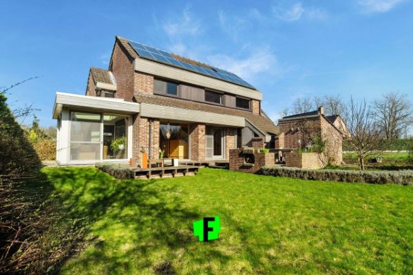
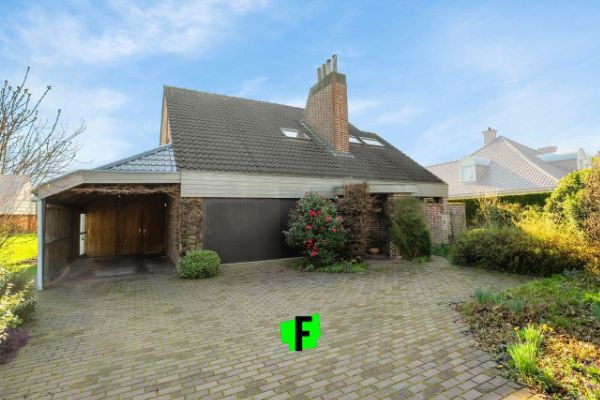
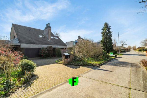
Aan de rand van Waregem treffen we deze vrijstaande woonst aan, met handelszaken, scholen, openbaar vervoer en invalswegen in de nabije omgeving.
Het perceel heeft een oppervlakte van 800 m² en een bewoonbare oppervlakte van 212m².
Het pand dateert van 1977.
De woning wordt betreden via de inkomhal die een directe toegang biedt tot de woonkamer met aansluitend de eetkamer, deze genieten van vele raampartijen en hebben als extra troef een houtkachel. Daarnaast bevindt zich de keuken met alle nodige toestellen.
De eerste verdieping bevat 5 slaapkamers, badkamer met wastafel en douche.
Op het tweede verdiep is er een bergzolder aanwezig die als polyvalente ruimte benut kan worden.
Uiteraard geniet deze topper van een dubbele beglazing en het huis wordt verwarmd via centrale verwarming op gas, er is alsook een regenwaterput en die heeft een inhoud van 12 000 liter. Ook beschikt de woning over een garage met een ruime oprit en een carport. De woning beschikt alsook over 16 zonnepanelen met groenestroom certificaten.
Aarzel niet en plan uw bezoek alvast in!
Troeven
*5 slaapkamers
* 1 badkamer
*Garage, carport en oprit
*Houtkachel als sfeermaker
*16 zonnepanelen 1) Urban development destination
Ra: Residential area
Rcha: Residential area with a cultural, historical and/or aesthetic value
Rp: Residential park
Rea: Residential expansion area
RaLc: Residential area with rural character
Ia: Industrial area
Ici: Industrial area for craft industries or areas for small and medium-sized enterprises
Dra: Day recreation area
Raa: Recreation accommodation area
Cpua: Community and public utility area
Aa: Agricultural area
Lvaa: Landscape with valuable agricultural area
Fa: Forest area
Na: Natural area
Nr: Nature reserve
Pa: Park area
Udna: Urban destination not available
2) Protected heritage: yes or no
3) Listed heritage:
Inventory of archaeological zones
Inventory of architectural heritage
Inventory of historic gardens and parks
Inventory of woody plants with heritage value
Landscape atlas
not applicable
4) Inspection certificate for electricity: yes (conform or not) or no
5) Renovation obligation: yes or no
6) Flood report:
Plot score or P-score: A: no flooding modelled B: small probability of flooding under climate change C: small probability of flooding D: medium
probability of flooding
Building score or G-score: A: no flooding modelled B: small probability of flooding under climate change C: small probability of flooding D: medium
chance of flooding
Location in signal area: yes or no
Location in defined riparian zone or defined flood plain: yes or no Heritage List: No / Site of untapped activity: No -
Listing features
Find detailed information about this property on Realo Explorer -
Cadastral features
Lot size 843m2 Parcel width 19m Parcel depth 45m Estimated garden area 685m2 Coordinates 50°54'29.8"N 3°27' 39.7"E Backside/Garden orientation South-East Building placement Detached P-Score D: Medium probability of flooding under current climate G-Score D: Medium probability of flooding under current climate -
Reveal the price history of Olmenlaan 99, 9870 Zulte via Realo Explorer
-
Popularity
8 views since listed For Saleon 25/04/24Property saved 1 time -
55%
Mobility score
This property has an average mobility score, based on the distance to nearby amenities.
-
Train stationWithin cycling distance
-
Bus stationWithin walking distance
-
Zulte City centerWithin walking distance
-
SchoolsWithin walking distance
-
StoresWithin walking distance
-
Highway exit2.4km away
-
-
Realo Estimate®
The Realo Estimate is the estimate of the market price of a property. A sale/rent estimate for Olmenlaan 99, 9870 Zulte is available now.
-
Realo Sale Estimate®████████ Show estimate
-
Realo Rent Estimate®████████/month Show estimate
Value your property instantly using Realo’s market-leading Automated Valuation Model. Each report includes local market trends, plus a valuation range and nearby recent sales. Order online and your report will be ready immediately for download.
Get the Estimate Report -
-
More about this property
For more information or to contact the seller:
View this property on ImmoVlan


-
-
Recommended
-
-